Great Britain
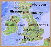
The United Kingdom of Great Britain and Northern Ireland lies at the northwestern edge of Europe, separated from the European mainland by the English Channel, the North Sea, and the narrow Strait of Dover. It consists of the formerly separate kingdoms of England and Scotland and the principality of Wales--which are collectively referred to as Great Britain--and the six counties of Northern Ireland, which elected to remain within the United Kingdom in 1921 when southern Ireland withdrew to form the Irish Free State (after 1949, the Republic of Ireland, or Eire). The loss of Ireland and its withdrawal from the Commonwealth of Nations in 1949 rendered politically obsolete the use of the collective term British Isles. Other integral parts of the United Kingdom are the outlying Hebrides, Orkney Islands, and Shetland Islands, off the coast of Scotland; Anglesey (see Gwynedd), off the coast of Wales; and the Isle of Wight and the Scilly Isles, off the southwest coast of England. Separate from the kingdom but administered by the crown, each with its own laws and systems of taxation, are the Isle of Man, located in the Irish Sea; and the Channel Islands, located off the northwest coast of France.
England is the largest and most populous unit in the kingdom, with an area of 130,439 sq./km. (50,363 sq./mi. ) and a population (1992 est.) of 48,378,300. Wales, located to the west and separated from England by a boundary dating back to the Middle Ages, has an area of 20,768 sq./km. (8,018 sq./mi. ) and 2,898,500 inhabitants; it became part of the English kingdom in 1282 but continues to maintain a separate language and national identity. Scotland--with an area of 78,772 sq./km. (30,414 sq./mi. ) and 5,111,200 inhabitants--lies to the north, separated from England by a boundary that extends from Solway Firth (estuary) on the west, across the sparsely populated Cheviot Hills, to north of Berwick upon Tweed. Scotland and England were ruled by the same monarchs after 1603 and were united in 1707 to form the kingdom of Great Britain. Ireland was made an integral part of the kingdom in 1801, changing the official name to the United Kingdom of Great Britain and Ireland. The present name was adopted after the partition of Ireland in 1921. Northern Ireland has an area of 14,121 sq./km. (5,452 sq./mi. ) and a population of 1,610,300. Commonly described as "in Europe but not of it," Great Britain and Ireland remained relatively isolated from world events until the 15th century when the Age of Discovery placed them on the world's newly charted sea-lanes and trading routes. Increasingly, the island nation looked away from Europe in later centuries and across the seas to the Americas, India, the Far East, southern and interior Africa, Australia, and New Zealand. Overseas colonies were established, forming the enormous British Empire. Many of these colonies chose to retain trade and other ties to Britain when granted independence and are today part of the Commonwealth; because of these ties, however, the United Kingdom's entry into the European Union (EU) in 1973 was preceded by lengthy negotiations and dispute. The Industrial Revolution began in the United Kingdom, which in the 19th century became the world's preeminent industrial and trading nation. In the 20th century, however, competition from more recently industrialized countries as well as the loss of its colonies (which had provided raw materials for Britain's industries and markets for their finished products) brought an economic decline. In the 1960s and 1970s severe labor disputes, unprecedented inflation, and declining exports contributed to a series of economic crises. During the Industrial Revolution the country became rapidly urbanized, and today more than 70% of the total population is concentrated in cities occupying 10% of the total land area. To protect the remaining countryside, national planning legislation has established ten national parks in the most scenic areas, including Dartmoor, the Lake District, the Pennines, the Snowdonia, the Pembrokeshire coast, North York Moors, Yorkshire Dales, Northumbria, Exmoor, and the Brecon Beacons. Other areas are also protected as Areas of Outstanding Natural Beauty.
LAND AND RESOURCES
Despite its small size, variety of scene is the main characteristic of the United Kingdom. Lowland England The largest area of flat plain occurs in The Fens, located on the east coast around The Wash. Before they were drained to produce a rich agricultural landscape similar to the polders in the Netherlands, The Fens were an area of marshland. Smaller flat areas are found along the Humber River estuary farther north on the east coast; along the Thames below London; and in Romney Marsh, in the southeastern county of Kent. Elsewhere, lowland England in the south and east is rolling country with a variety of landforms reflecting differences in underlying rock types. Especially prominent are the low hills and scarps developed on chalk rocks of Cretaceous age (135 million to 65 million years ago). They occur in the North and South Downs to the south of London, where the scarps face south and north, respectively, into The Weald; in Salisbury Plain, where the downs converge at their western end; and in the low hills that continue westward through the southern counties of Wiltshire and Dorset and swing eastward through the Isle of Wight. Northwestward from Salisbury Plain, the chalk hills form the prominent Chiltern Hills to the northwest of London; fall to lower elevations in the hills of East Anglia (Norfolk and Suffolk counties); and farther north form the Lincoln and York Wolds on either side of the Humber estuary. To the west, separated from the chalk hills by an intervening lowland developed mainly on clays, rise a northeast-trending series of uplands developed on limestones of Jurassic age (190 million to 135 million years ago). They extend from the southern county of Dorset to the North York moors on England's northeast coast, and include the Cotswolds, which form a scarped edge overlooking the River Severn valley and rise to a high point of 314 m (1,031 ft) in Cleeve Cloud, near Cheltenham. Also prominent in lowland England are the Mendip Hills, which rise to 326 m (1,068 ft) in Black Down, in the southwest near Bristol; Exmoor, which rises to 520 m (1,707 ft) in Dunkery Beacon farther west; Dartmoor, a granite-formed upland that rises to 621 m (2,039 ft) in High Willhays in the southwestern peninsula; and the Malvern Hills, which exceed 300 m (1,000 ft) between Gloucester and Worcester. Glacial deposits greatly modify topography and landforms north of an irregular line joining the River Thames and the Bristol Channel; often burying the underlying rock to considerable depths, the mantle of glacial deposits creates differing soil conditions as well as different drainage conditions from field to field.
Upland England Uplands predominate in northern and western England. The most extensive uplands are the Pennines, which rise to 893 m (2,930 ft) in Cross Fell. Underlain mainly by limestones and grits of Carboniferous age (345 million to 280 million years ago), the Pennines are bordered on both sides by discontinuous coalfields, and the open moorlands of the Pennines contrast starkly with the sprawling industrial cities near the coal deposits. Numerous broad river valleys, known locally as dales, drain eastward across the mountains into the Vale of York, a north-south extension of lowland England that serves as the main route northward into Scotland. West of the Pennines are the Lancashire and Cheshire Plains and farther north England's scenic Lake District, which rises to 978 m (3,210 ft) in Scafell Pike, England's highest peak.
Wales and Scotland Unlike England, the topography of Wales and Scotland is dominated more by mountains and uplands than by lowlands. The highest mountain in Wales is Snowdon, which rises to 1,085 m (3,560 ft) in the northwest. In South Wales the Brecon Beacons rise to 886 m (2,907 ft) and, as in the Pennines, the barren, windswept uplands contrast with the deep and generally narrow coal-mining valleys farther south. The principal lowlands in Wales are on the island of Anglesey and along the western coasts of Caernarvon and Cardigan bays. Southern Scotland is dominated by low ranges of the Southern Uplands, which rise to elevations exceeding 610 m (2,000 ft) in parts of the Tweedsmuir Hills. To the north of the Southern Uplands are the geologically complex, down-faulted Scottish Central Lowlands that extend northeastward across the country from the Firth of Clyde on the west coast to the firths (estuaries) of Tay and Forth on the east coast. The lowlands are interpenetrated by uplands, including the Pentlands, Campsies, Ochils, and Sidlaws; all rise over 300 m (1,000 ft), with peaks reaching over 610 m (2,000 ft) in the Ochils. North and west of the Central Lowlands are the Highlands, a large upland region divided by the Glen More (Great Glen), a deep depression that extends from Fort William to Inverness and is occupied in part by Loch (lake) Ness. Narrow lowlands border the Highlands in the east. The western Highlands are rugged and mountainous and include Ben Nevis, the highest point in the United Kingdom. Numerous other peaks reach over 1,200 m (4,000 ft) in the Cairngorm Mountains, the most extensive area of mountainous terrain in the Highlands. On the western island of Skye, the scenic Cuillin Hills rise to more than 900 m (3,000 ft) in places, with lower, moorland-covered peaks common on the other islands of the Inner and Outer Hebrides.
Northern Ireland The structural depression forming the Scottish Central Lowlands extends southwestward across the Irish Sea to form the area of lowlands surrounding Lough (lake) Neagh, which is situated to the west of Belfast in Northern Ireland. Scenic mountains of low elevation border the lowlands area on all sides. To the northeast rise the Antrim Mountains, which reach a high point of 554 m (1,817 ft); formed on basaltic rocks of Eocene age (54 million to 38 million years ago), the mountains reach the sea on the north coast in the famous steps of the Giant's Causeway. The Sperrin Mountains form the northwestern edge of the depression and reach a high point of 683 m (2,240 ft) in Mount Sawel. Forming parts of the southern edge of the depression in part are the Mourne Mountains, which are located south of Belfast and which rise to 852 m (2,796 ft) in Slieve Donard, the highest point in Northern Ireland.
Soils The richest soils include the reclaimed alluvial deposits in The Fens, alluvial soils along the Mersey River and west coast, and brick earths and other deep soils used for fruit and vegetable cultivation in the London basin. Elsewhere, soil fertility varies greatly because of underlying rock differences, but modern methods of fertilization make natural fertility less important than such other conditions as soil texture, drainage, climate, and slope. In general terms, soils in the drier east and south are used mainly for crops, and soils in the more humid west and north and in some clay areas are used mainly for dairying. Sheep are grazed generally on poorer soils in moorland and upland areas.
Climate
The United Kingdom has a highly variable temperate marine west-coast type of climate. Relatively few periods of continuously dry weather occur; they are usually caused by anticyclonic systems and are associated with unusually warm days in summer and cold periods in winter. Much more common is the variable weather that occurs as cyclonic depressions sweep in from the Atlantic Ocean, bringing high winds and abundant rainfall to the west in winter and lower amounts of rainfall in summer. Mountainous west coast areas generally receive more than 2,540 mm (100 in) of rain a year, but rainfall amounts diminish rapidly eastward; the Cairngorm Mountains receive only about 1,000-1,270 mm (40-50 in) a year, and most lowlands in the west, between approximately 500 and 750 mm (20 and 30 in). The driest areas surround the Thames estuary in southeastern England, where less than 500 mm (20 in) of rain falls each year. In the wetter western areas, 2 out of 3 days are usually rainy; in the drier east, rain falls on almost one out of every two days. No permanent snows exist, but snow may lie on the ground for 2 months or more in the Cairngorm Mountains and other parts of the Highlands. In winter, temperatures are colder in the east than in the west; snow covers the ground for about 18 days in Aberdeen, an average of 6 days in London, and hardly at all along the entire southern coast or the west coast as far north as Glasgow. In summer, a more normal decrease in temperature from south to north occurs; average July temperatures range from about 17 degrees C (63 degrees F) on the southern coast and in London, to 12 degrees C (54 degrees F) in the north of Scotland.
Drainage The Severn and Thames are the longest rivers. Other major rivers are the Avon, Clyde, Forth, Mersey, Tay, Trent, Tweed, Ouse, Tees, and Tyne. These and other rivers are all used either for shipping, water supplies, or hydroelectric power; their flow is, accordingly, highly regulated. Many of the rivers are canalized and are linked with other river systems in an intricate, and now largely abandoned, canal system dating from the early Industrial Revolution. Drinking water is derived from subsurface supplies and from numerous reservoirs in the Pennines, in the Welsh mountains, and in Scotland. Untreated sewage effluent no longer enters the major rivers, and even the Irwell--which runs through Manchester and was once described as the "hardest-worked river in the world" (and certainly the filthiest)--is now clean enough for fishing.
Vegetation and Animal Life
Although forests cover only 7% of the land area, the British landscape presents a characteristically wooded appearance. This impression stems mainly from the presence of many trees in hedgerows and pastures, coverts planted for game birds, shelter belts planted beside farmhouses and exposed fields, and ornamental plantings on great estates. Little remains of the original oak and birch forest cover, and most of today's forests consist of pines and other conifers planted in reforestation programs in depopulated areas of Scotland and Wales. The largest forests in England occur in the Breckland to the northeast of Cambridge; in Kielder Forest in Northumberland; and as the remnants of the historic Forest of Dean (in Gloucestershire) and Sherwood Forest (in Nottinghamshire); and the New Forest (in Hampshire), a former royal hunting preserve. More extensive than forests are the expanses of treeless moorland that cover much of the Pennines, Highlands, and other exposed upland areas; on the drier moors heather predominates, and on the wetter moors, various grasses and mosses. Extensive areas of alpine flora occur at high elevations in the Cairngorms and other parts of the Highlands. Game birds include grouse, on the moors, and pheasants. Deer are hunted with horses and hounds on Exmoor; deer stalking (on foot) is preferred in the Scottish Highlands. Foxes are hunted in rural areas.
Resources
The United Kingdom has long been rich in energy resources but deficient in food and industrial raw materials. Extensive coal deposits occur around the eastern and western edges of the Pennines, in South Wales, in the western Midlands (Birmingham area), and in the Scottish Central Lowland. Easily accessible coal seams are, however, largely exhausted. Fortunately for the energy-hungry British economy, large deposits of petroleum and natural gas under the North Sea came into commercial production in 1975; by the end of the 1980s the United Kingdom is expected to be self-sufficient in petroleum. Other mineral deposits are of small importance. They include tin, mined in small amounts in Cornwall; low-grade iron ores in the Jurassic rocks of Lincolnshire and Northamptonshire in the eastern Midlands, used in steel mills at Scunthorpe and Corby; kaolinite (china clay), mined in parts of Cornwall; and sands and gravels, quarried for road-building materials. Of the total land area about 25% is used for crops and more than 65% for grassland and grazing; agricultural productivity has been greatly improved since World War II, and only one-third of all food needs are now imported, compared with two-thirds before the war.
PEOPLE
Except in the case of recent immigrants, the British population tends to classify itself more in terms of national and regional origins than by racial or ethnic criteria. About 83% of the total population live in England, 9% in Scotland, 5% in Wales, and 3% in Northern Ireland. About 4% are non-Caucasian immigrants who arrived in recent decades from the British West Indies, Pakistan, India, and other Commonwealth or former Commonwealth countries. Earlier efforts to recognize in the nonimmigrant population various Nordic, Alpine, and Mediterranean racial strains are now questioned, and the most that can be said with authority is that the population is primarily descended from a mixture of Europeans that have at different times invaded and occupied the islands. Traces of early settlement go back to the Paleolithic era, but the first main occupation was by Celts, who came by direct migration from continental Europe and also as travelers along the western sea routes linking Brittany to Cornwall, Ireland, Scotland, and the Orkney and Shetland islands. The Roman occupation began in AD 43. Most of the English Lowland was eventually romanized, but outlying areas of Wales, the Pennines, the Lake District, and Scotland remained a nonpacified zone from which Celtic marauders might unexpectedly attack. Anglo-Saxons came after the decline of Roman Britain and colonized most of the English lowland after the 5th century; they failed, like the Romans, to colonize the north and west, and the division between an Anglo-Saxon south and east and a predominantly Celtic north and west has persisted to this day. Danes settled alongside the English in the 9th century and briefly controlled northeastern and central parts of the English lowland as the Danelaw. The Danish invasions were part of large-scale Viking movements from the 9th to 11th centuries. Other Vikings (Norse) sailed the western sea routes and settled in the Orkney and Shetland islands, along the west coasts of Scotland, in Ireland, in the Lake District, and in western coastal areas as far south as the Isle of Man. Normans conquered England in 1066. Anglo-Normans had conquered Wales by 1284 but did not anglicize the population much beyond the towns and castles they established along the lowland fringes of North and South Wales; they were also unable to subdue the Scots. Added to this early ethnic mixture were later refugees from continental Europe, such as the French Huguenots; many Irish migrants in the 18th and 19th centuries; Poles and other displaced persons during and after World War II; and since the 1960s more than 3 million Asian, West Indian, and other nonwhite immigrants. Historically, most immigrants have in time been absorbed into British society following an initial period of tension.
Languages
The official language is English. Other languages include the Celtic languages Welsh, the national language of Wales, and Scottish Gaelic, so named to distinguish it from Irish Gaelic, the national language of Ireland. In 1991, Welsh was spoken by 508,098 people, or about 18% of the total Welsh population, down from 715,000 in 1951. Most Welsh speakers are concentrated in the rural northern and western counties of Wales, where they constitute most of the total population; all but a few are also recorded as English speaking. Welsh nationalism has been strongly linked with encouraging the wider use of Welsh, and since the Welsh Language Act of 1967, the language has enjoyed parity with English in governmental and legal matters throughout Wales. Scottish Gaelic was spoken by 65,978 in 1991, down from 95,500 in 1951; it is used primarily in the western Highlands and on the islands. The Scottish nationalist movement is less concerned with promoting Gaelic as a national language for Scotland than with improving economic and social conditions by diverting a greater share of North Sea oil profits to Scotland in the future. Cornish, once used in the southwestern peninsula, and Manx, used on the Isle of Man, are virtually extinct.
Religion
The Anglican Church of England and the Presbyterian Church of Scotland are established national churches, but neither is subsidized by the state. Wales has no established church, nor has Northern Ireland, which is approximately two-thirds Protestant and one-third Roman Catholic. The Church of England has the nominal, if not the practical, support of about 60% of the English; about 40% of all Scots support the Church of Scotland. Roman Catholicism is heavily represented in Liverpool, Manchester, Glasgow, and other large industrial cities with large numbers of Irish and continental European immigrant workers. Methodist, Baptist, and United Reform (Presbyterian and Congregational) churches are found almost everywhere in England and Wales; in Scotland the Episcopal (Anglican) church has small numbers of adherents in most towns and a few villages. Other Christian groups include the Society of Friends (Quakers) and the Salvation Army. About 350,000 Jews live in the United Kingdom, mainly in the London area. In addition, recent immigrants have established Islamic mosques and Hindu and Sikh temples in some of the major cities.
Demography
The birthrate is 14 (1991) per 1,000 inhabitants and the death rate 11, representing a slightly wider range than that of 1981 and a marked change from the mid-1970s, when birth and death rates were virtually balanced at 11.7 per 1,000 inhabitants, giving a near-zero rate of population growth. It appears that these changes may represent a long-term trend. The population is highly urbanized, and the United Kingdom is the third most densely populated nation in Europe (after the Netherlands and Belgium). The most densely populated part of the United Kingdom is England, with 354 persons per sq./km. (917 per sq./mi. ); Scotland has a density of 63 per sq./km. (163 per sq./mi. ); Wales, 135 per sq./km. (349 per sq./mi. ); and Northern Ireland, 112 per sq./km. (290 per sq./mi. ). About 32% of the total population is concentrated in the Greater London area and seven other conurbations (continuously built-up urban areas)--Glasgow City district, Tyne and Wear (based on the central cities of Newcastle upon Tyne and Sunderland), Merseyside (Liverpool and environs), Greater Manchester, West Yorkshire (based on Leeds and Bradford), South Yorkshire (based on Sheffield), and the West Midlands (Birmingham and the Black Country). Another substantial portion of the population is urbanized in smaller towns with more than 50,000 inhabitants, including the environs of Belfast and Cardiff. The most sparsely populated areas are the Highlands of Scotland, upland areas of Wales, and the Pennines. According to the 1991 census, the most rapid recent population growth has occurred in the regions of East Anglia, particularly the county of Cambridgeshire; the South West; and the East Midlands. The county of Buckinghamshire, outside the Greater London area, also has experienced increases. The fastest-growing districts are generally the remoter, mainly rural districts--such as South Hams, North Dorset, and Suffolk Coastal; the districts that include the post-1945 new towns (designed to relieve urban congestion)--such as Milton Keynes, Redditch, and Bracknell Forest; and resort, port, and retirement districts--such as East Dorset and Colwyn. By contrast the most significant decreases were generally in the principal cities in metropolitan districts, such as Liverpool, Manchester, and Glasgow, and in Inner Lon don boroughs. Also in decline were old textile and other industrial towns of the Pennines--such as Bolton, Oldham, Burnley, and Blackburn for cotton and Bradford, Halifax, and Huddersfield for woolens. Stagnation has occurred in the industrialized northeast of England and in much of Scotland.
Education and Health
Education is free and compulsory for all children between the ages of 5 and 16. Nursery schools are also provided for children under 5, but the supply of such schools does not meet the demand. In most cases children in the British education system move from a junior to a senior school at age 11, with some local authorities choosing to transfer children at age 12 or 13. Current educational policy is for comprehensive schools to educate all children up to age 16. A minority stay on in school until 18 or 19 and join a sixth form (upper class level) in the school that prepares them for entrance to university or other forms of higher education. In some areas special sixth form colleges are provided. The majority of the school population, however, leave school at 16 and either go to work or continue education in colleges of further education, technical schools, or colleges offering vocational training on either a full-time, part-time, or evening basis. Evening school classes enroll large numbers of adults in a wide range of academic and recreational classes. The old grammar schools are now almost completely merged into the comprehensive system of education, although some have chosen to become independent. As independent schools, they, like such prestigious "public" (private) schools as Eton College, Rugby School, and Winchester College, no longer receive state aid but are required to maintain the same standards of staffing and equipment as the state schools; like them, too, they are subject to periodic inspection. Higher education is prov ided at 34 universities in England and Wales, including the prestigious universities of Cambridge, London, and Oxford; at eight in Scotland; and at two in Northern Ireland. In addition, six university colleges, including a medical college, are allied with the University of Wales, and the Open University provides instruction and degrees for home-based students via national television channels (see British education). Medical care is provided free or for a small charge to most of the population through the National Health Service. In addition, a small minority financially able to do so choose to remain outside the system and be private, fee-paying patients of hospitals, physicians, and dentists. Under the National Health Service, small charges are made for prescriptions (except for children and senior citizens), for dental treatment, and for optical and other special services. Normally, no costs are incurred by the patient for routine medical care, including visits to the doctor's office, house calls, or hospitalization as a patient or outpatient. Principal causes of death are heart and circulatory diseases and cancer.
The Arts
More than 64,000 book titles were published in 1990 in the United Kingdom, with fiction as the largest category. The best-know university presses are at Oxford and Cambridge, but most other publishers maintain their headquarters in London and, for the Scottish presses, in Edinburgh and Glasgow. For the nation's vast literary heritage see separate entries on English literature, Scottish literature, and Welsh literature. Foremost painters include William Hogarth, Thomas Gainsborough, Joseph Mallord William Turner, John Constable, and William Blake (see English art and architecture). The works of these and other painters are maintained in London at the National Gallery, Tate Gallery, and other galleries and in some larger cities outside London. Special art exhibitions by the Royal Academy in London attract large crowds every year. Leading composers of English music include Henry Purcell, Edward Elgar, Ralph Vaughan Williams, and Benjamin Britten. The Albert Hall and Royal Festival Hall are important concert centers in London, and first-class orchestras are maintained in London, Liverpool, Manchester, and Birmingham and by the BBC (British Broadcasting Corporation). The Glyndebourne Opera Festival, Royal Ballet, Royal Opera, and English National Opera (formerly Sadler's Wells Opera) are all internationally famous. In Wales eisteddfods, festivals of music (especially choral music) and art, are held throughout the year, the most famous being the Royal National Eisteddfod. In Scotland the major event in the arts is the 3-week annual Edinburgh International Festival of Music, Drama, and Art at the end of the summer. Other important cultural events in Britain are the Chichester Festival, the Shakespearean plays at the Royal Shakespeare Theatre in Stratford-on-Avon, and local music and drama festivals. The main source of government support for music and drama is the Arts Council.
ECONOMIC ACTIVITY
In the 14th and 15th centuries, England developed a flourishing wool trade with the Continent and a cottage-based textile industry in sheep-raising areas of the Cotswolds, Pennines, East Anglia (Norwich area), and the southwest. In the 18th century the invention of power-driven textile machinery revolutionized this earlier industry, and spinning and weaving operations moved out of the home and into factories. Early factories were powered by running water, and the abundance of this waterpower (and of soft water for the wool-washing processes) concentrated the early textile industry in the Pennines. Steam engines, fueled by coal, replaced water power after the 1780s, and the coalfields developed as major industrial centers. Lancashire (west Pennines) developed as a cotton textile center; Yorkshire (east Pennines), as the center of woolen manufactures; Birmingham and the Black Country (West Midlands), as a center for the manufacture of machinery and precision equipment; and the Glasgow area, as a shipbuilding and metallurgical center. By 1851 the United Kingdom was the world's leading industrial nation. It lost this industrial preeminence after the 1920s as other nations began to industrialize. Its economy continued to decline in relation to those of other developed countries, and after much indecision, it joined the European Economic Community in 1973.
Manufacturing Workers directly engaged in manufacturing number approximately 5.5 million, or less than 17% of the total labor force. Of these, about 29% are engaged in the metallurgical and engineering industries, about 5% in chemical industries, about 10% in food processing, and 6% in textile manufacturing. About 10% work in vehicle manufacture, and 8% work in the paper, printing, and publishing industries. Increasing efficiency of production and elimination of uneconomic plants continue to reduce the numbers working in manufacturing. The main centers of industry are on the coalfields of northern England and Scotland, in the western Midlands, and around the major ports, including London.
Agriculture
Approximately three-fourths of all the land area of England and Wales is used for farming, excluding moorlands used for grazing; in Scotland less than one-fourth of the total area is farmed. The main crops are wheat, barley, oats, peas, beans, vegetables, sugar beets, and green fodder crops; most are grown in the east and south of England, on the east coast of Scotland, and on the Lancashire and Cheshire plains. Livestock farming, mainly for beef and dairy products, prevails in lowland areas elsewhere, with sheep farming predominant on higher ground. Truck farming (called market gardening in the United Kingdom) is important near London and other large cities and on the south coast. Flowers and early potatoes are a specialty in mild and sheltered areas of Cornwall and the Scilly Islands. Less than 2% of the total labor force is engaged in agriculture, and the number of people working the land has declined steadily since 1945 in the face of increased mechanization and greater agricultural efficiency.
GOVERNMENT
The United Kingdom is a constitutional monarchy with a parliamentary form of government. The ruling sovereign (since 1952) is Queen Elizabeth II; the heir apparent is Prince Charles, who by tradition as the eldest son of the monarch is Prince of Wales. As head of state the sovereign ceremonially opens each new session of Parliament and entrusts executive authority to the prime minister (since 1990, John Major) and the cabinet. Legislative authority rests with a bicameral Parliament, but effective power lies more with the directly elected House of Commons (lower house) than with the House of Lords (upper house), consisting of hereditary and life peers. The prime minister is appointed by the sovereign as the leader of the majority party or coalition of parties in the House of Commons. The maximum term of Parliament is five years, but elections may be called earlier if the government loses the support of the Commons or if it chooses. The principal political parties are the Conservative party (which holds the majority of seats in Parliament), led by John Major, and the Labour party, led by Tony Blair. Other parties include the Liberal Democrats, formed as the Social and Liberal Democrats in 1988 by a merger of the Liberal party and the Social Democratic party (led by Paddy Ashdown); the Communist party; and the locally important Ulster Unionist, Scottish National, and Plaid Cymru (Welsh Nationalist) parties. Of the 651 members in the Commons, 524 represent England, 38 represent Wales, 72 represent Scotland, and 17 represent Northern Ireland. The Isle of Man and the Channel Islands have separate local assemblies and are self-governing. Plans to provide devolution (home rule) to Scotland and Wales ended in 1979, when voters in Wales rejected a plan to establish a Welsh assembly in Cardiff, and voters in Scotland approved, but with less than the necessary majority, establishment of a separate assembly for Scotland in Edinburgh. Home rule had been in effect for Northern Ireland (since 1921) but was ended in 1972 because of continuing Protestant-Catholic hostilities. Government of Northern Ireland now rests with the secretary of state for Northern Ireland, who is answerable to the Parliament in London. Agreements between the British government and the government of Ireland in 1985 and 1995 attempted to create a more cooperative framework in which the conflict in Northern Ireland might eventually reach a peaceful resolution. Local administration in England is managed through 39 nonmetropolitan and 7 metropolitan counties. The metropolitan counties are London, Tyne and Wear, Merseyside, Greater Manchester, West Yorkshire, South Yorkshire, and the West Midlands. The nonmetropolitan counties are subdivided into 297 districts. Wales is divided into 8 counties, subdivided into 37 districts; Scotland is divided into 9 regions and 3 "island districts"--Shetland, Orkney, and the Western Isles--and subdivided into 53 districts. Northern Ireland is divided into 26 districts. British dependencies overseas include Gibraltar, Bermuda, British Virgin Islands, Falkland Islands, Turks and Caicos Islands, Cayman Islands, Montserrat, Hong Kong, the British Indian Ocean Territory, Saint Helena, Ascension, Tristan da Cunha, and the Pitcairn Islands.